Debby to hit Southeast Georgia, Lowcountry with heavy rain, flooding, & strong winds
ISOLATED TORNADO THREAT. BUT ALSO STREET FLOODING AND WITH WIND GUSTS TOPPING ABOUT 50MPH, WE ALSO COULD SEE SOME POWER OUTAGES AS WELL. SO DEFINITELY KEEP THIS IN MIND. AGAIN, THIS STARTS TO RAMP UP STARTING MONDAY AFTERNOON, SO I’LL TOSS IT OVER TO CHIEF METEOROLOGIST JEREMY NELSON FOR A LOOK AT MORE DETAILS AS WE HEAD TOWARDS TOMORROW WITH DEBBIE’S IMPACTS. YEAH, WE’RE PROBABLY JUST A FEW HOURS AWAY FROM HAVING A HURRICANE IN THE GULF OF MEXICO. RIGHT NOW, WINDS ARE AT 65MPH. THIS IS OFF TO THE WEST OF TAMPA, TRACKING ITS WAY TO THE NORTH. NOW, THAT SLOW DOWN OR NEAR STALL IS GOING TO OCCUR SOMEWHERE ACROSS SOUTHEAST GEORGIA BEFORE IT GETS KICKED OFF TO THE NORTH AND EAST. SOMETIME A LITTLE BIT LATER THIS WEEK. NOW, THE UPDATED FORECAST TIMING. LET’S STEP YOU THROUGH THIS LANDFALL TOMORROW MORNING. THAT COULD BE MAYBE AROUND 8 A.M. AND THEN THAT TRACK OFF TO THE NORTH AND EAST. AND THESE ARE TROPICAL STORM SYMBOLS. SO THIS IS THE POSITION HERE AT 2 P.M. ON TUESDAY. SO AGAIN VERY SLOW MOVING AFTER LANDFALL. AND THEN IT CURVES ITS WAY OFF TO THE NORTH AND EAST WEDNESDAY THURSDAY AND INTO FRIDAY. SO MAYBE NOT THE BIGGEST WIN MAKER FOR US, BUT ALL KINDS OF RAIN IS EXPECTED. SO WE’LL TALK WIND AND RAIN HERE. BUT LET’S START YOU OFF WITH THE CURRENT TROPICAL STORM ALERTS. YELLOW SHADED COUNTIES. TROPICAL STORM WATCH THAT COULD EASILY BE FLIPPED TO A TROPICAL STORM WARNING TONIGHT BECAUSE IMPACTS REALLY RAMP UP AS WE GO THROUGH MONDAY INTO MONDAY NIGHT. AND THEN DOWN ACROSS MUCH OF SOUTHEAST GEORGIA. THOSE ARE TROPICAL STORM WARNINGS. SO YES, IT’S COMING YOUR WAY. ALL OF THAT RAIN IN THOSE WINDS, THAT RAMP UP 40 MILE PER HOUR GUSTS OR HIGHER. IT’S SO QUIET RIGHT NOW, THOUGH. HARBOURTOWN LIGHTHOUSE. WE’LL LOOK AT THIS CAMERA OVER THE NEXT 24 TO 60 HOURS. AND YOU’RE GOING TO SEE A A CHURNED UP CALIBOGUE SOUND OUT THERE. THESE BOATS WILL BE BOBBING UP AND DOWN, AND THE FLAGS, THEY’LL BE WHIPPING AROUND AS WELL. SO OUR FUTURECAST, LET’S STEP YOU THROUGH THIS MIDNIGHT TONIGHT. OVERNIGHT, WE COULD HEAR SOME RUMBLES OF THUNDER AND SOMETHING WE HAVE TO WATCH GOING INTO MONDAY. THESE OUTER BANDS THAT START ROTATING IN SOME OF THOSE WILL HAVE A LITTLE SPIN WITH THOSE ISOLATED TORNADO THREAT FOR OUR AREA. NOW, AS WE GO INTO MONDAY AFTERNOON, SOME OF THOSE TORRENTIAL DOWNPOURS STARTING TO OVERSPREAD AREAS NEAR AND SOUTH OF THE ALTAMAHA RIVER AND AGAIN, ANY OF THESE THUNDERSTORMS MAY HAVE SOME SLIGHT ROTATION. WE HAVE A SLIGHT RISK OF SPIN UP TORNADOES ACROSS THE AREA. TORRENTIAL RAIN COMES IN MONDAY EVENING, CONTINUES MONDAY NIGHT INTO TUESDAY. THE DIFFERENCE TUESDAY, THOUGH THERE WILL PROBABLY BE A COUPLE CAUSE OF HEAVY RAIN AND THEN SOME LOCATIONS SEE VERY LIGHT RAIN FOR A TIME AND THEN YOU MIGHT SPIN BACK INTO SOME OF THESE BANDS OF RAIN FROM THE AFTERNOON INTO THE EVENING HOURS. BY TUESDAY INTO WEDNESDAY, WE WATCH THAT AREA OF LOW PRESSURE TRACK ITS WAY OFF TO THE NORTH AND EAST. SO LET’S HIGHLIGHT THIS AREA SHADED IN YELLOW. IF YOU GET A TORNADO WARNING FOR YOUR AREA TOMORROW, KNOW WHAT TO DO. STAY AWAY FROM WINDOWS AS MANY WALLS BETWEEN YOU AND THE EXTERIOR OF YOUR HOME. SO BASICALLY JUST STAY HOME THE NEXT COUPLE OF DAYS IF AT ALL POSSIBLE. WITH THIS TROPICAL SYSTEM. OVERSPREADING OUR AREA FLOOD WATCH. THIS GOES UNTIL FRIDAY. REALLY, THE RAIN COMES DOWN THOUGH TONIGHT, MONDAY, TUESDAY INTO PART OF WEDNESDAY. ALTHOUGH ALL THE RUNOFF WE COULD HAVE SOME RIVERS AT FLOOD LEVELS OR BEYOND COMING UP AND THIS MAY BE A RECORD RAINFALL FOR OUR AREA. LET’S TAKE YOU THROUGH THIS. PAUSING AT 6 P.M. MONDAY. BY THAT TIME, ALREADY LOOKING AT THREE TO MAYBE UPWARDS OF EIGHT INCHES OF RAIN DOWN ACROSS APPLING AND WAYNE INTO MCINTOSH COUNTY. AND WHEN IT’S ALL SAID AND DONE, RAINFALL TOTALS PRETTY CONFIDENT. 8 TO 14IN 1 OR 2 LOCATIONS ACROSS OUR AREA COULD BE A LITTLE BIT CLOSER TO 18IN WHEN IT IS ALL SAID AND DONE. SO THAT’S WHY WE ARE VERY CONCERNED ABOUT SOME FLOODING ACROSS THE AREA. IT ALL STARTS ON MONDAY. WIND GUSTS INITIALLY HIGHEST AT THE COASTLINE. SOME OF THOSE TROPICAL STORM FORCE WIND GUSTS WILL START OVERSPREADING THE AREA MONDAY NIGHT, FLOODING POSSIBLE. AND THEN ON TUESDAY, NOT AS MUCH RAIN, BUT THERE WILL BE POCKETS OF TORRENTIAL DOWNPOURS MIXED IN AND PREPARING FOR DEBBY. JUST THE SIMPLEST OF THINGS YOU CAN DO RIGHT NOW. SECURE THAT PATIO FURNITURE, ANYTHING THAT COULD BLOW AROUND DURING THE STORM. HAVE YOUR PHONES CHARGED AND DEVICES READY TO GO IN CASE YOU LOSE POWER. AND PLEASE DON’T PARK OR DRIVE THROUGH FLOOD PRONE AREAS. THERE WILL BE SOME FLOODING ACROSS OUR AREA, AND IF YOU WANT THOSE WEATHER ALERTS SENT DIRECTLY TO YOU, JUST DOWNLOAD THE FREE WJCL 22 NEWS APP. THREE ALERT DAYS COMING UP MONDAY, TUESDAY, WEDNESDAY. REALLY HOPEFUL THE STORM IS OUT OF HERE. THEN AS WE GO INTO THURSDAY WITH JUST A FEW SHOWERS LEFT OVER FOLLOWING WEEKEND, MAYBE A LITTLE BIT OF CLEANUP TO DO FOR OUR AREA. SO WE’RE HOPEFUL. SATURDAY IS DRY AND THEN JUST SOME TYPICAL SUMMERTIME WEATHER IS BACK. ISLANDS AND BEACHES. YOUR WIND GUSTS AGAIN MONDAY INTO TUESDAY, 50MPH OR HIGHER, AND YOU’RE ALSO LOOKING AT THAT AT LEAST 8 TO 14IN OF RAIN WEEKEND FORECAST COMING UP FOR NEXT WEEKEND. DEFINITELY QUIETER AROUND 90 DEGREES AND JUST A SLIGHT CHANCE OF A SHOWER OR A THUNDERSTORM. SO WE’LL CONTINUE TO MONITOR THE
Debby to hit Southeast Georgia, Lowcountry with heavy rain, flooding, & strong winds
Debby is set to deliver heavy rain, flooding, and gusty winds across Southeast Georgia and the Lowcountry now through Tuesday night. The torrential downpours may lead to record rainfall in parts of the area.There is also the threat for isolated tornadoes and some coastal flooding.Let’s start with the forecast tracks. The storm is forecast to slowdown after it makes landfall in the Big Bend area of Florida.A turn to the northeast is forecast taking the storm across Southeast Georgia from Monday night through Tuesday. Debby will slowly move northeast, possibly moving over the Atlantic Ocean as it tracks up or near the Southeast Coast. The storm may turn inland over the Carolinas by Wednesday or Thursday.The number one impact from Debby will be heavy rain. Rainfall totals of 8″-14″ are forecast for much of the area. Isolated totals may reach 18″ in spots. Street and river flooding is likely from this storm. Please do not drive through flooded roadways!Here is a look at the rainfall forecast from the IBM/GRAF computer model. This lines up well with the official WJCL 22 rainfall forecast of up to 18″ in isolated locations. Rain should become more scattered and isolated on Wednesday. The heaviest rain is Monday, Monday, and into parts of Tuesday.The threat of isolated tornadoes is highest on Monday across our area. Please stay weather aware as thunderstorms rotating around Debby may produce spin-up tornadoes. Download the free WJCL 22 News App and you can get weather alerts sent directly to you in the event a tornado warning is issued for your area. A Storm Surge Warning is in place for Coastal Georgia and the Lowcountry. Storm surge of 2-4′ is possible. The wild card is if this will paired up with any of the high tides in our area. Right now major coastal flooding is not expected, but a lot will depend on the timing of the higher water. Check back for updates!For the latest weather information and the area’s certified most accurate forecast watch WJCL 22 News or check the free WJCL 22 News App. You can get weather updates anytime on social media…follow on X here or on Facebook here.Jeremy NelsonWJCL 22 Chief Meteorologist
Debby is set to deliver heavy rain, flooding, and gusty winds across Southeast Georgia and the Lowcountry now through Tuesday night. The torrential downpours may lead to record rainfall in parts of the area.
There is also the threat for isolated tornadoes and some coastal flooding.
Let’s start with the forecast tracks. The storm is forecast to slowdown after it makes landfall in the Big Bend area of Florida.
A turn to the northeast is forecast taking the storm across Southeast Georgia from Monday night through Tuesday. Debby will slowly move northeast, possibly moving over the Atlantic Ocean as it tracks up or near the Southeast Coast. The storm may turn inland over the Carolinas by Wednesday or Thursday.
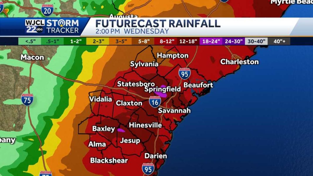
The number one impact from Debby will be heavy rain. Rainfall totals of 8″-14″ are forecast for much of the area. Isolated totals may reach 18″ in spots. Street and river flooding is likely from this storm. Please do not drive through flooded roadways!
Here is a look at the rainfall forecast from the IBM/GRAF computer model. This lines up well with the official WJCL 22 rainfall forecast of up to 18″ in isolated locations. Rain should become more scattered and isolated on Wednesday. The heaviest rain is Monday, Monday, and into parts of Tuesday.
The threat of isolated tornadoes is highest on Monday across our area. Please stay weather aware as thunderstorms rotating around Debby may produce spin-up tornadoes. Download the free WJCL 22 News App and you can get weather alerts sent directly to you in the event a tornado warning is issued for your area.
A Storm Surge Warning is in place for Coastal Georgia and the Lowcountry. Storm surge of 2-4′ is possible. The wild card is if this will paired up with any of the high tides in our area. Right now major coastal flooding is not expected, but a lot will depend on the timing of the higher water. Check back for updates!
For the latest weather information and the area’s certified most accurate forecast watch WJCL 22 News or check the free WJCL 22 News App. You can get weather updates anytime on social media…follow on X here or on Facebook here.
Jeremy Nelson
WJCL 22 Chief Meteorologist


